 By Stan Levin
Through the 1960’s and 70’s I taught in the city’s public elementary schools. Each year I told my students about the history of a severe drought that San Diego had been experiencing up until late January, 1916.
A brilliant scoundrel, one Charles Hatfield, arrived on the scene, and convinced the public he could make it rain, but the distraught citizens would need to fork over $10,000 for it.
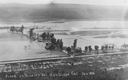
Be reminded that most of the county was watershed at the time, and the end of the line watershed was low lying Mission Valley, where rainwater from all directions ultimately found its way, and emptied into the sea downstream.
 Hatfield did make it rain as promised, you can read all about it. And it rained and it rained and rained some more, until a person could only cross the Valley by boat.
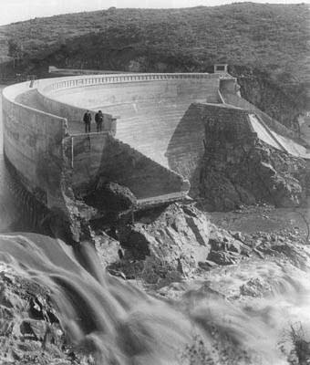 The Otay Reservoir dam (I showed where that was to my students) collapsed on January 27th, 1916.
 Now, dear readers, this flood plain of a valley has been covered with so-called “development”; concrete and tarmac, and wall to wall buildings and rooftops of every sort.
 The watershed is no more, and water falling on San Diego has nowhere to go to be absorbed by the natural soil.
In San Diego’s not too far off future – please listen, class, – scientists tell us the “hundred year flood” is predictable. Not if, but when the storm arrives, the Valley will fill towards its rim. When the flooding recedes, most of the existing “development” in the Valley will be gone, destroyed and washed out to sea on the tide. The losses will be monumental.
 Remember you had a teacher who told you this was going to happen during your lifetime.


{ 9 comments… read them below or add one }
Be it coincidence or not, we have 2 posts that mention or talk about Mission Valley in the past. Take this opportunity to check out these pics from the huge flood in San Diego in January 1916.
Dear readers: please see the additions to our righthand sidebar, such as “Top Posts & Pages”, “Recent Posts”, and then our list of authors with their last post listed. Tell us what you think of this “new” look, please.
I like the new additions to the sidebar!
I don’t think so. The climate has changed too much. Guess again…
It isn’t 1916 any more…
Patrick in Point Break the hundred year storm…I been onto this before and can hardly wait to see what happens. Unfortunately, In valleys like in Escondido they put up some massive Mc mansions right in the center of what is a dried river bed. New homes hopefully won’t be built there again if this weather takes form as bad as it had before?
People forget but there was an even bigger flood in the 19th century (1862). Mission Valley was so badly flooded that ships were able to tie up approximately where Mission Valley shopping center is located. There was no ability to get from San Diego to Oceanside as every coastal lagoon was flooded, wiping out what land routes that were exisiting at that time, with only travel by sea possible. The lowlands of Point Loma and False Bay (now Mission Bay) were also flooded.
This post is not intended to deny anthropogenic climate change, just an interesting historical fact.
I swear people forget about EVERYTHING when it comes to history. It’s like a mental block or something!
I remember the beach evacuation the day of the Anchorage Alaska quake and expecting to not have a house to live in later that afternoon. Look at MB now! If it wasn’t for the 30 foot height limit it would look like Miami Beach which of course is also built on a transitional sandbar. Oh wait! Sand? Transitional? Together they mean…not good.
Huge OB apartment buildings on SANDstone cliffs…which continue to crumble because they are, after all, only compacted sand! Anybody around OB have an ‘office pool’ going as to which building on the Cliffs will fall into the ocean next? Hey, people do it for sports games why not real life?
Schools and hospitals on top of earthquake faults, re-building communities ripped apart by tornadoes in the same place…above ground. We’ll build on the sides of dormant volcanoes and directly on top of previous eruption pyroclastic flows. We fill floodplains and all three coastlines right up to the edge of the oceans. Chemical factories and refineries on rivers, and nuclear plants. I mean, really?
And it’s not just us, this is a worldwide! In Japan, the last mega-quake 300+ years ago off the Pacific Northwest coast sent a tsunami so far inland that they built large carved markers that said “DO NOT BUILD CLOSER TO THE OCEAN THAN THIS” for their descendants just to remind those later generations. Roughly five miles inland. They had huge monuments to that giant wave! So what did the silly humans do? Went and put nuclear reactors on the beach and built cities around the monuments and then had a quake just as big right off their own coast…while that mega-quake fault line off our NW coast that caused the first one is overdue for another quake just as big.
Makes one wonder about our…grasp of reality as a species doesn’t it? Kind of spooky.
So imagine this: think of that ‘bomb’ cyclone which stalled over the upper Midwest and just freaking drowned that entire area of the country. So San Diego has a Pineapple Express version sitting directly over head for a week. Or two. Or three. A ‘Bomb Express.’ Feet of water falls, literally. Or maybe another hurricane will turn north like back in the 1930s and drop feet of water in 48 hours of total madness. Why not? According to the latest science I’ve read the planet has roughly 5-7% more water in the atmosphere from the destabilizing and warming climate than it used to. Gotta fall somewhere, right?
Somebody should post an old geological map that shows the natural drainages without the modern build-up! Anybody have access to one of those? Then side by side it with a current aerial photo to compare the two. That would be interesting to see.
sealintheSelkirks
In 1978-’80 there was an oil painting in the Presidio Mission building from the years when the Indians were ministered to (after 1769? or 1862′?) It clearly showed Mission Valley filled to the rim from side to side. ..perhaps the current population using up the reservoirs’ waters are what has kept it from flooding in the 1900’s (ie. they’re very low), but the amount that actually ‘rains’ into Mission Valley can easily cause havoc…just like it did a few years ago next to OB’s beach with a ‘new multi-residential’ lot…it was not the 100 yr. flood, nor were the several flood periods experienced the last 40 yrs. Unfortunately, it appears San Diego prefers ‘not to learn from history,’ so is doomed to respeat it.
It is November 8th, 2022. The wind is picking up this morning in San Diego. Heavy rain is forecast. Will Hatfield the Rain-maker be vindicated today? I am watching the bending magnolia tree in my backyard, and wondering if this might be “the day”
Stan Levin